After a couple rounds of bowling we made our way to Rapid City from Murdo, SD. The models show that the Cap will break down around the Black Hills this afternoon with the CAPE being 1000-1500J/kg. The trough is between here and Phillip.
What we are actually looking at is cloudy skies and cool temperatures with NE breeze - we are hoping for the best. :)
Go back to Murdo and wait. It will probably go just before dark but persist late into the evening due to the strengthening LLJ. You might get a backlit tor if storms do form and remain sfc based. Wave moving through should allow storms to form in that area in its wake as cooler air moves in aloft.
ReplyDeleteGood luck!
We are following a storm outside of Wall, SD currently. Severe TS warned right now.
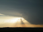
ReplyDeleteStorm was tornado warned. We waited for the storm to pass over hyw 73, outside of Philip. We were going to look for hail but were stopped by the town police. They said that someone had reported a tornado up ahead about 15ish minutes prior to this post. We turned around and headed back to town.
ReplyDeleteSo he stopped you from chasing? Boo!
ReplyDeleteAre you gambling with the Minnesota play today or are you going to get set up for tomorrow?
Looks great for discrete tornado producing beasts!
So southern Minnesota today and southern Oklahoma tomorrow (?). How long is that drive? I might take a look at some stuff today...
ReplyDeleteMaybe lunch in Willmar or Mankato? Want to be in backed surface winds as you know...not ideal co-location of instability and shear today but should be able to see something. Focus on low-level (e.g., 0-1km shear) where there are high values of CAPE and deep-layer shear...Good Luck!
ReplyDeleteOr maybe a little further east...not sure how good visibility is out that way though.
ReplyDelete