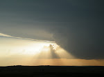
After the nocturnal tornado producing storm north of Philip, SD on Monday night, the goal now shifts to getting on a tornado producing storm that we can actually see. A moderate risk in the southern plains should provide us with this opportunity. We drove from Chamberlain, SD to Hutchinson, KS today, where we'll stay the night and prepare for tomorrow.
We'll hopefully be set up close to the triple point of the surface low by late morning/early afternoon where storms should initiate first, before working themselves east down the warm front and south down the dryline. Stay tuned for more updates
Tough one for you guys today with all the nocturnal junk around. Looks like KS is the place to be though for low-level shear so hopefully things clear out enough to tap into both the deep and low-level shear to spin something up.
ReplyDeleteMaybe somewhere near Colby, KS in the next couple of hours?
ReplyDeleteBut maybe only a narrow window of opportunity before the storm moves to the NE into the capped environment...
ReplyDeleteIn Great Bend still now, and I'm starting to think moving a bit north and west may be our best play
ReplyDeleteWe are currently heading straight west of Great Bend. Not sure if we will head north or south at this point.
ReplyDeleteGuess you went northwest right? Looks like nothing singnificant materialized. There were tornadoes in NE but chasing would have been difficult with the MCS mode there. Careful if you're in East OK today, hills and trees are not your friends...good luck.
ReplyDelete