After our tour at the NWS yesterday we noticed that some storms popped up along a dryline. We decided to head towards Tulsa, OK from Norman. The storms fizzled out and moved out of the region by the time we had reached Tulsa.
We then turned north-westward and are heading back home.
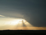
May 8, 2011
Friday, 13 May 2011
Tuesday, 10 May 2011
Moderate Risk on the Southern Plains
After the nocturnal tornado producing storm north of Philip, SD on Monday night, the goal now shifts to getting on a tornado producing storm that we can actually see. A moderate risk in the southern plains should provide us with this opportunity. We drove from Chamberlain, SD to Hutchinson, KS today, where we'll stay the night and prepare for tomorrow.
We'll hopefully be set up close to the triple point of the surface low by late morning/early afternoon where storms should initiate first, before working themselves east down the warm front and south down the dryline. Stay tuned for more updates
We'll hopefully be set up close to the triple point of the surface low by late morning/early afternoon where storms should initiate first, before working themselves east down the warm front and south down the dryline. Stay tuned for more updates
Monday, 9 May 2011
Bowling for Convection
After a couple rounds of bowling we made our way to Rapid City from Murdo, SD. The models show that the Cap will break down around the Black Hills this afternoon with the CAPE being 1000-1500J/kg. The trough is between here and Phillip.
What we are actually looking at is cloudy skies and cool temperatures with NE breeze - we are hoping for the best. :)
What we are actually looking at is cloudy skies and cool temperatures with NE breeze - we are hoping for the best. :)
Sunday, 8 May 2011
Weak Week
After a week of sunny blue skies we are finally (hopefully) getting some action. With the cap being so strong in Oklahoma and area we have moved northward into Nebraska. We are currently sitting at Valentine, Nebraska. Our position is based on proximity to the warm front and we seem to be in the moist tongue. Along with the other important variables, everything is seeming to line up overtop.
Subscribe to:
Posts (Atom)